This was a first for TBF. As you can imagine, having a piece of technical equipment thrusting through salt water at high speeds when attached to a marlin is not 100% fail-proof. Some detach prematurely, some get predated by sharks, and battery failure is often another factor inhibiting the collection of data throughout the preprogrammed durations of satellite tags.
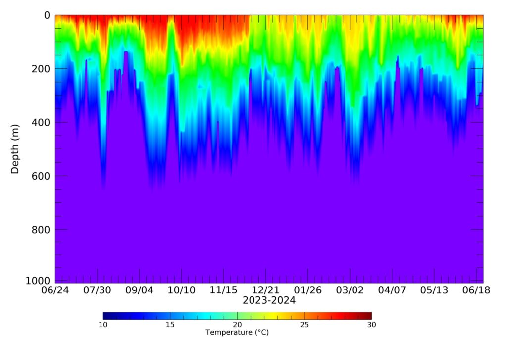
This tag was part of research conducted by TBF and the Gulf Coast Research Lab, part of the University of Southern Mississippi, under the guidance of Drs. Jim Franks and Jeremy Higgs. The tag was programmed for 12 months, but continued to report after it popped off the marlin. Satellite tags collect a range of data, depending on the scientific query, including movement, depth, water temperature and light intensity at pre-programmed intervals, which are then compiled into histograms before being sent to the Argos satellite.
The data provides scientists with insights into the distribution of marlin throughout a range, how they use habitat depth either seeking prey, avoiding becoming prey, finding food, how does the fish’s depth relate to fishing depth in an area, does the tagged marlin darkness, twilight and full daylight, how much time does the tagged fish spend at each water level, were any very deep dives made, how deep.
Once collected data is analyzed, scientists can help suggest fishery management and conservation changes needed. For instance, should commercial fishing patterns be changed to catch more or less to help conserve the species? The data variables are tremendous. Deployment of at least five to eight tags in an area within close time intervals provides a better sample size from which scientists can draw conclusions. One tag alone, like the successful 12-month tag, provides feedback on that one fish.
Other tags were deployed in relatively the same time as the 12-month tag, but for various reasons did not report adequate data from which to draw broader conclusions. This marlin’s deepest dive was to 338 meters or 1108.92 feet and traveled over 27,000 miles!
TBF’s scientist, the late Dr. Phillip Goodyear, discovered in earlier research that blue marlin can dive to depths of over 2,000 feet. Goodyear’s 2006 study of 48 tagged blue marlin found that the mean dive depth was 318.6 meters, with most dives ranging from 200 to 300 meters. This marlin also swam a total of 27,812 miles (44,760km), with a daily average of 75.96 miles.

In terms of speed, this marlin averaged 3.15 mph with a max speed of 23 mph! The analyzing scientist, Dr. Jiangang Luo, commented that this marlin’s speed is very much equivalent to Usain Bolt’s speed for 100 meters, 9.82 seconds!
Satellite tagging broadens our understanding of highly migratory marlin, billfish, tuna, and sharks. If interested in participating in a satellite tagging project or separately sponsoring a tag, at $6,500 each, please contact us at [email protected]. Keep in mind there are different designs of satellite tags, some are best matched with fish that spend more time near the surface, like sharks, and others are better suited for those that swim throughout the water column.
TWO ADDITIONAL SATELLITE tags were deployed during 2023 in the Gulf of Mexico on blue marlin by TBF board member Scott Cooper from Fairhope, Alabama. The first tag was deployed on May 13, 2023 and recorded for three months before popping off early, 6,780 miles from the original tagging location. The average daily distance swum 73.59 miles at an average speed of 3.07 mph and 16 seconds is the time for the 100-meter dash.
The second tag was deployed on September 3, 2023 recorded data for five months before popping off early, 3,118 miles from the original tagging location. Average daily distance swam 76.21 miles at an average speed of 3.18 mph, and 15 seconds is the time for the 100 meter dash.


